
Location and area size
The territory of Gunung Walat University Forest (GWUF) is located geographically between 6o54’23” – 6o55’35” S and 106o48’27”-106o50’29” E, and administratively within the territory of Cibadak subdistrict and Cicantayan subdistrict, the regency of Sukabumi. In terms of forest administrative territory, GWUF belongs to BKPH Gede Barat, KPH Sukabumi, Perum Perhutani Unit III Jawa Barat and Banten. Area size of the forest territory is 359 ha. GWUF consists of three blocks, namely East Block (Cikatomas) as large as 120 ha, West Block (Cimenyan) as large as 125 ha, and Central Block (Tangkalak) as large as 114 ha. The forest territory is shown in Figure 1:
- North : Village of Batununggal and Village of Sekarwangi
- East : Village of Cicantayan and Cijati
- South : Village of Hegarmanah
- West : Village of Hegarmanah
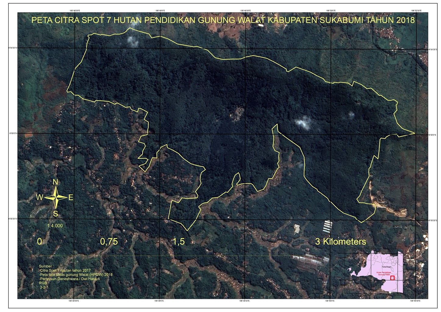
Figure 1. Gunung Walat University Forest territory
Physical Condition
Topography
GWUF is situated at elevation of 460-726 m above sea level. Gunung Walat constitutes a part of a hilly region which stretches from east to west. The southern part is a rolling area along hill ridges which stretches and sloping in undulating manner from north to south. The topography ranges from undulating to hilly, especially in the southern side, whereas in the northern part, the topography is progressively steeper. In the central part, there are peaks with altitude of 676 m asl, exactly at triangulation point KQ 2212; and at the western part at elevation of 726 m asl in point KQ 2213. Nearly the whole territory is situated at elevation of above 500 m asl. Only less than 10 % of the territory (in the southern part) is situated below that elevation.
Climate
Climate in GWUF, according to Schmidt and Ferguson classification, is categorized as type B climate, with Q values = 14. 3% – 33% , and the amount of annual rainfall ranges between 1600-4000 mm. Maximum air temperature at day time is 29˚C and the minimum temperature at night time is 19˚C. On the other hand, on the basis of Koeppen classification, GWUF climate is categorized as wet tropical climate with rainfall of 2400 mm per year with monthly rainfall ranging from 75 mm per month (June and July) to the maximum of more than 300 mm per month (in December and March) (Figure 2).
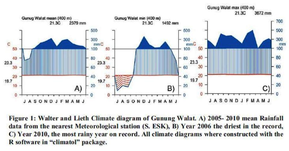
Figure 2. Walter and Lieth climatic diagram of Gunung Walat University Forest territory
According to meteorological data recorded in base camp of GWUF since November 2010, average monthly temperature is 22.6oC with maximum temperature of 29oC and minimum temperature of 19.1oC. Average relative humidity is 95% with extreme humidity ranging from 100% to 66%.
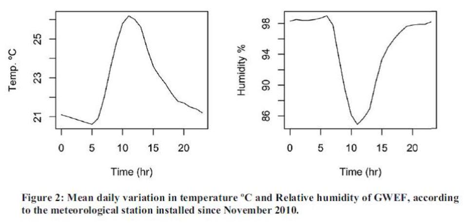
Figure 3. Average daily variation for temperature and relative humidity in year 2010 (up to November) in the territory of Gunung Walat University Forest.
Hydrology
GWUF possesses 7 small rivers which flow the whole time during the year. These rivers flow southward, and are used by local people.
Geology
Prayitno (1965) in Marwitha (1997) explained that content of natural rocks in Gunung Walat comprise volcanic and sedimentary rocks which have greenish gray color, forming three series of very thick layer. Thickness of each layer range from several cm to ± 35 cm. Results of mapping by Musper (1939) in Prayitno (1965) in Marwitha (1997) showed that Gunung Walat comprise layers of dacitic tuff which in particular horizon are interspersed by andesitic tuff rocks, which constitutes a part and formation of “old breccias” of Miocene age. Condition of Gunung Walat constitutes a Miocene island in the center of Quarternary volcanic rock formation originated from Mount Salak and Mount Gede.
According to Geology Map of Bogor-Jawa sheet (1974), Gunung Walat and the surrounding areas are developed by lower tertiary sedimentary rocks (Oligocene) which are referred to as Walat formation. Walat formation is composed mainly by cross bedded quartz sand rocks, quartz boulder conglomerate, carbon clay, lignite and thin charcoal layer. The higher the position, the greater would be the particle size and it is exposed in Gunung Walat (near Cibadak) and the surrounding areas. Sands from this formation could be used for production of glasses, and it is estimated that the thickness is between 1000 and 1373 meters (Musper, 1939 in Effendi, 1974 in Marwitha, 1997).
According to Effendi et.al (1998) in Praptisih et.al (2009), stratigraphically, the oldest rocks in Sukabumi areas are Walat formation which are composed by cross bedded quartz sand rocks, quartz boulder conglomerate, carbonaceous clay rocks, and thin layers of coal. The higher the position, the greater would be the particle size, and it is exposed in Gunung Walat and the surrounding areas (Figure 4 and 5). Age of the rocks is estimated to be early Oligocene. Above it, Batuasih formation is deposited harmoniously and consists mainly of green marl clay rocks with pyrite concretion.
In several places, there are many small and large fossils of foraminifera which are estimated to have the age of late Oligocene. Thickness of this rock reaches 200 m, and is exposed in Kampung Batuasih. Afterwards, it is deposited as Rajamandala formation which is composed by tuffaceous marl, marly clay, sandstone and limestone lenses which contain fossils of Globigerina oligocaenica, Globigerina praebulloides, Orbulina, Lepidocyclina, and Spiroclypeus which provides age range of late Oligocene – Early Miocene. This formation is superimposed inharmoniously above Batuasih formation with thickness of around 1100 m. Limestone members of Rajamandala formation which consist of coral reef limestone with a small number of fossils of Lithothamnium, Lepidocyclina sumatrensis, and Lepidocyclina (Eulepidina) ephippiodes, are usually dolomitized. Above them, Halang formation is deposited which consists of tuff members in the form of dacitic tuff sandstone, andesite tuff, and breccia members in the form of andesite breccias/tuffaceous dacite, limestone, and marly claystone. In some places, limestone layers contain fossils of Trillina howchini, Lepidocyclina brouweri, and Globorotalia mayeri, which provide age indications of Early Miocene. This member constitutes the lowest part of Jampang formation which is superimposed harmoniously above Rajamandala formation. Afterwards, toward the upper part, there are old volcanic rocks which comprise: (1) Volcanic rocks of Pangrango, older sediments, lahar, lava, and basalt-andesite rocks, and (2) Volcanic breccias, breccia composed of andesite – basalt, localized agglomerates and decayed materials.
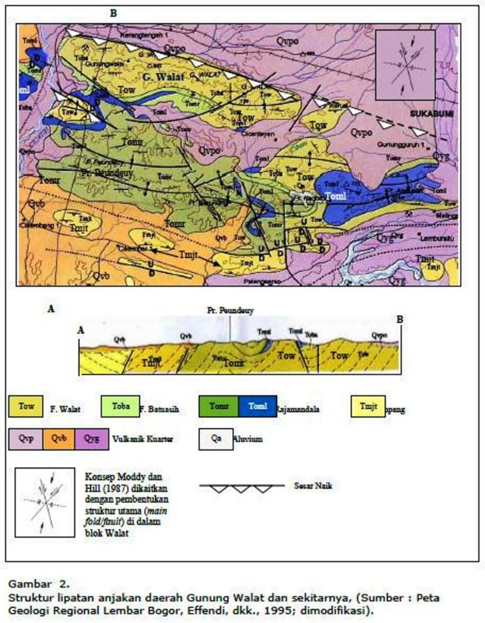
Figure 4. Folding and thrusting structure of Gunung Walat and the surrounding area
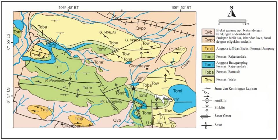
Figure 5. Geological map of Gunung Walat and the surrounding areas.
Soil types
According to soil map of Gunung Walat (1981) (scale 1:10 000), Gunung Walat soils belong to the family of Typic Tropohumults (Podsolic soils), Typic Tropodults (Red Yellow Podsolic soils), Typic Dystropept (Red Latosol), and Typic Troporthent (Lithosol). Red Latosol is the most abundant soil type. In rocky areas, there is only Lithosol, and in valley area, there are Podsolic soils (Figure 6).
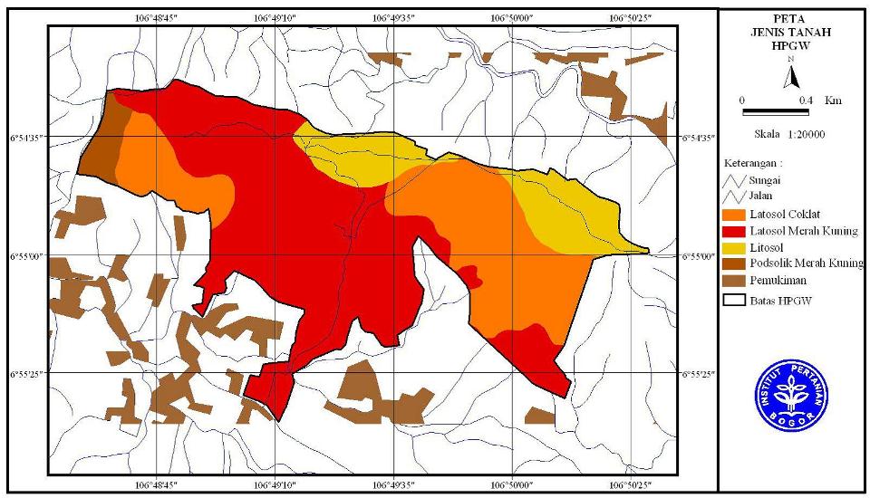
Figure 6. Soil types in the territory of Gunung Walat University Forest
Biotic condition
Land cover
Condition of Gunung Walat area in the year 1950s was mostly in the form of bare land covered with bush, imperata grass and several trees which grew very sparsely. A picture of the initial land cover condition of GWUF area is shown in Figure 7.
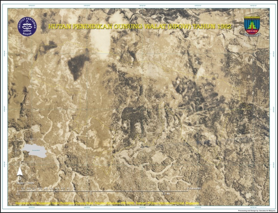
Figure 7. Map from imagery of year 1982, showing condition of land cover of GWUF area.
At present, condition of land cover was 70% vegetated with dominant stands of agathis (Agathis loranthifolia) and mixed species (Pinus merkusii, Pinus ocarpa, dan Schima wallichii) created from planting activities in the year 1951/1952 (Figure 8 and 9). The other 30% of the area is covered by stands whose age are just 1 – 40 years, comprising sonokeling (Dalbergia latifolia), Acacia auriculiformis, Acacia mangium, and rasamala (Altingia excelsa), and several native species which are deliberately maintained. Beside trees, there are also ferns, epiphytes, and various herbs and species. There are also barren area of ± 113,5 Ha which comprise failed reforestation area, former dry land farm area , former burnt area and encroached area.
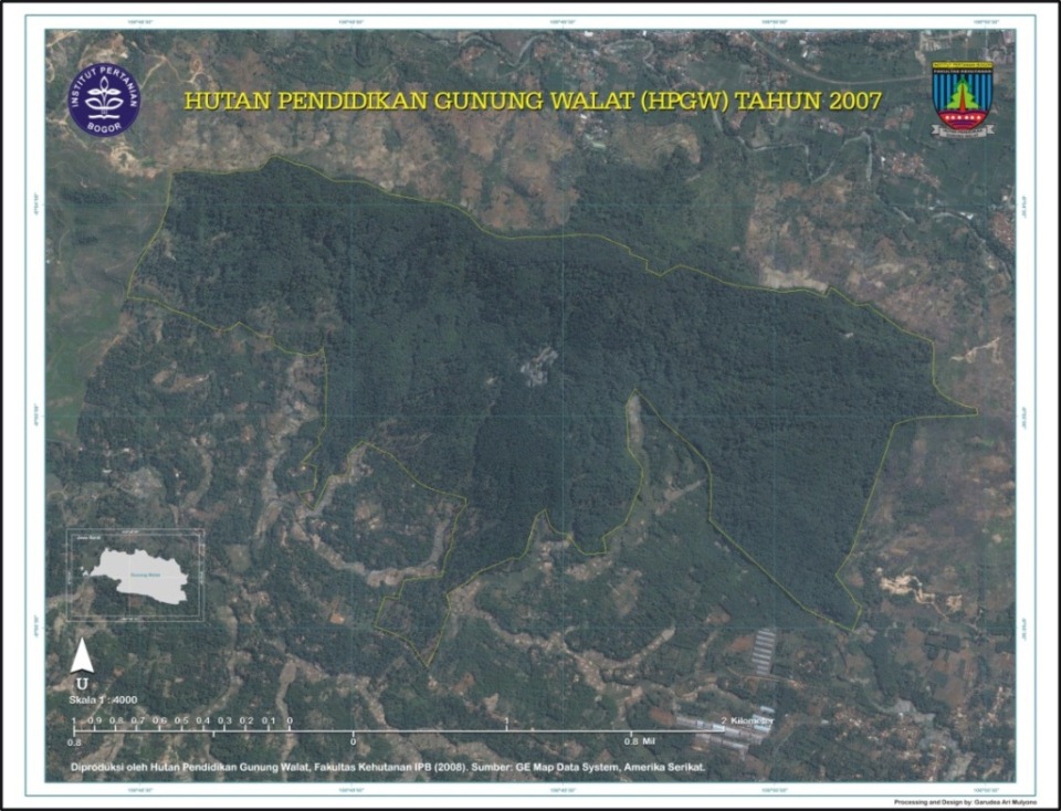
Figure 8. Map from imagery of year 2007 showing land cover condition of GWUF area
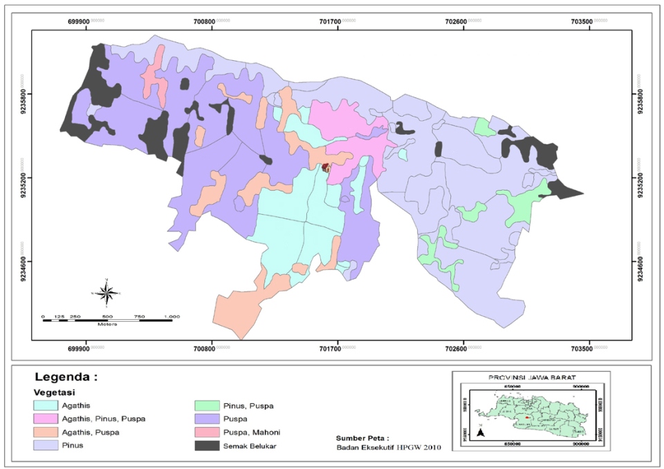
Figure 9. Map of land cover in the area of GWUF
Condition of vegetation
In the year 1951, the area of GWUF started to be planted with agathis (Agathis loranthifolia). The area in which such planting was conducted in the year 1951-1952, at present has become dense agathis (dammar) stand around the basecamp. Afterwards in the period of year 1969-1971, there was planting of pine, puspa and kayu afrika, while in the period of year 1971-1972 there was planting of agathis. In the year 1973 the planting has reached 53%. In the year 1980 the whole territory of GWUF had been planted with various tree species, namely dammar (Agathis lorantifolia), pine (Pinus merkusii, P. insularis, P. oocarpa), puspa (Schima wallichii), kayu afrika (Maesopsis eminii), mahogany (Swietenia macrophylla), rasamala (Altingia excelsa), sonokeling (Dalbergia latifolia), gamal (Gliricidae sp), sengon (Paraserianthes falcataria), meranti (Shorea sp), and acacia (Acacia mangium).
At present condition, forest stand in GWUF is dominated by tree species dammar (Agathis loranthifolia), pine (Pinus merkusii), sengon (Paraserianthes falcataria), mahogany (Swietenia macrophylla) and other species, such as kayu afrika (Maesopsis eminii), rasamala (Altingia excelsa), Dalbergia latifolia, Gliricidae sp, Shorea sp, and akasia (Acacia mangium). In GWUF, there are at least 44 species of non tree vegetation, comprising among others, 2 species of rattan and 13 species of bamboo.